

SOLUTION & SERVICE
KES provides integrated geospatial solutions by leveraging satellite imagery, Earth observation data, and advanced geospatial technologies through its strategic partnerships.
By combining satellite data resources, analytical capabilities, and digital geospatial platforms, KES supports a wide range of applications including environmental monitoring, land management, infrastructure analysis, and disaster response.
Through collaboration with its partner organizations, KES delivers end-to-end services ranging from data access and analytics to project implementation and decision-support solutions tailored to customer needs.
OMS: Order Management System
CESNAP is CES’s in-house order management platform designed to manage the full lifecycle of satellite imagery, from request to delivery. It allows customers to purchase tasked or archived imagery directly and monitor their order status in real time.


Greenhouse Gas Monitoring and Analysis Services
Monitoring greenhouse gas concentrations and hourly emissions (kg) is the first step toward a cleaner Earth.
Using shortwave infrared (SWIR) data from environmental satellites, this technology measures concentrations of greenhouse gases such as carbon dioxide (CO2) and methane (CH4) and analyzes emission patterns. It supports both large-area monitoring and facility-level source detection, enabling continuous trend analysis and accurate source identification. This capability helps customers achieve their carbon reduction goals while supporting science-based climate action and informed policy development.

Carbon Credit Project Development
We provide carbon credit value to governments and businesses through the measurement, reporting, and verification (MRV) of greenhouse gas emissions measured by environmental satellites. Revenue generation through emissions trading systems (ETS) contributes to cost reduction, regulatory compliance, enhanced market competitiveness, and strengthened brand value for demand-side stakeholders.

Water Resource Management
To tackle the global water scarcity challenge, we leverage AI to analyze the distribution, depletion, and trends of water resources, delivering key insights for informed decision-making in drought response, flood management, and reservoir operations.
We also provide continuous monitoring of rivers, lakes, and reservoirs, tracking water quality changes, pollution spread, and algal blooms, to safeguard aquatic ecosystems and ensure reliable access to safe water

Marine Environment Management
We monitor and analyze changes in marine ecosystems, including ocean temperatures, pollution sources such as oil spills, the movement of harmful species, and occurrences of red tides. We deliver scientific insights to support the conservation of marine environments and the sustainable management of coastal and ocean resources.

Collaborative Solutions Worldwide
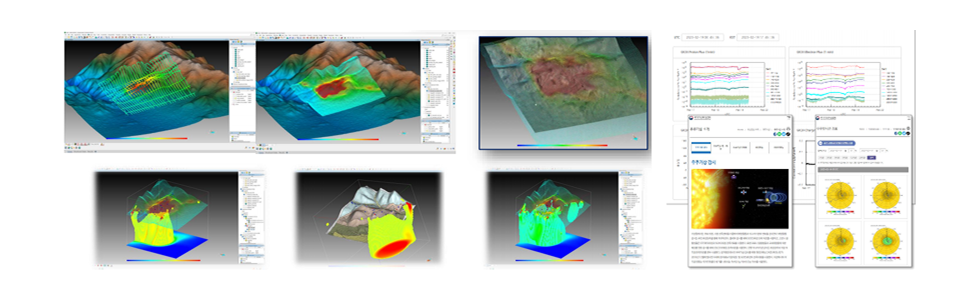
Korea Institute of Geoscience and Mineral Resources (KIGAM): Subsurface Resource (Mineral) Exploration Solutions
SpaceWare: Space Radiation Analysis, Space Weather Data Analysis, SWIS (SpaceWare Image Integration System)
Methane Emissions Monitoring
We detect, localize, and quantify methane (CH4) plumes from industrial assets and landfills with high precision, helping companies meet ESG targets, comply with tightening environmental regulations, and eliminate costly product loss from leaks.

Wildfire Monitoring
We provide end-to-end solutions for wildfire management, combining near real-time thermal anomaly detection with advanced predictive models. By integrating satellite-derived fuel moisture maps, topography, and live meteorological data, our models simulate fire propagation paths, allowing emergency services to optimize containment strategies and protect vulnerable communities before the flames arrive. We also provide daily fire danger indices by integrating satellite-derived fuel moisture maps, topography, and live meteorological data, providing a granular risk assessment before ignition occurs.

Water Body Monitoring
To ensure water safety and infrastructure resilience, we offer advanced hydrological monitoring that combines satellite analytics with high-precision drone-based bathymetry to create detailed 3D digital bottom models. Our technology tracks the dynamic changes in water mirror area and reservoir levels, while our predictive engines simulate complex flood scenarios and potential dam breach impacts to identify high-risk zones. By integrating real-time surface monitoring with sophisticated hydrodynamic modelling, we deliver critical early warning systems and actionable insights for flood management and the protection of critical water infrastructure.

Oil Spill Monitoring
Utilizing Synthetic Aperture Radar (SAR) for all-weather, day-and-night surveillance, we offer rapid detection of oil films on the ocean surface. Beyond mere detection, our hydrodynamic models forecast the drift and weathering of spills based on sea currents and wind patterns, enabling maritime authorities and energy companies to coordinate effective cleanup operations and identify potential polluters.

GIS Portal Development
We bridge the gap between complex geospatial data and intuitive decision-making by building custom, high-performance GIS portals. Our web-based platforms integrate diverse data layers—from satellite imagery and IoT sensors to cadastral records—into a secure, user-friendly interface, empowering your team with automated reporting, spatial query tools, and real-time visualization of critical assets.

Land Displacement Monitoring (InSAR)
We leverage Interferometric Synthetic Aperture Radar (InSAR) technology to measure ground and structural deformations with millimeter-scale accuracy. This non-invasive monitoring is essential for the structural health of bridges, dams, and tunnels, as well as for tracking land subsidence caused by mining, groundwater extraction, or seismic activity, ensuring long-term safety and infrastructure resilience.
